Why did Hurricane Otis 'explosively' intensify off Mexico? / Photo: - - NOAA/AFP
 Grieving Deschamps to miss France's final World Cup group game

 Cubans bid farewell to revolution hero Valdes

 Ronaldo delights in silencing 'attacks' after making World Cup history

 'Paris in this heat is awful': Tourists change plans as sites close early

 'I'm back': Ronaldo scores at sixth World Cup as Portugal run riot

 US TV news host begs for info after kidnap note says mother is dead

 Ronaldo scores at sixth World Cup as Portugal run riot

 Portugal's Ronaldo first man to score at six World Cups

 Rubio says US will not accept Iranian tolls on Hormuz

 Marco Rubio in Gulf to reassure allies hit hard by Mideast war

 American Michele Kang agrees deal to buy French club Lyon

 French farmers suffer arid crops, heat-stricken animals

 Scorching heat shuts Paris landmarks early as France swelters

 Ipswich hire Gary O'Neil as manager

 Lake wins Wales captaincy race ahead of Morgan

 Starmer vows 'orderly' transition as Labour MPs mull bid to be PM

 ACTIVIST SHAREHOLDER FILES SCHEDULE 13D IN EQUUS TOTAL RETURN, INC.

 Europe: the world's fastest-warming continent

 Gennaro Gattuso returns to coaching with Lazio after Italy debacle

 Why the heat is wreaking havoc on Europe's trains

 Seoul leads rout for tech shares as oil prices dip

 India monsoon sweeps north but brings less rain than usual

 UK and markets await Burnham's economic plans

 Banned Vondrousova insists she has 'never doped'

 UN chief urges AI firms to 'come clean' over environmental footprint

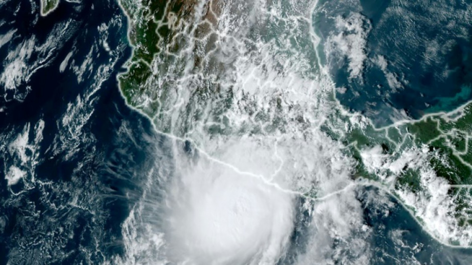
Hurricane Otis caused at least 27 deaths and major damage as it battered Mexico's beachside city of Acapulco as a scale-topping category 5 storm, according to officials.
The speed with which Otis rapidly intensified took the government and weather forecasters by surprise, leaving little time to issue warnings and prepare for its arrival.
Why was Otis so devastating?
"Otis's intensification was very exceptional. It was nearly record-breaking in some ways," said Michael Brennan, director of the Miami-based National Hurricane Center (NHC).
Within hours Otis strengthened from a tropical storm to the most powerful category of the five-step Saffir-Simpson scale before hitting land early Wednesday.
Otis "explosively intensified" with peak wind speeds increasing by 115 miles per hour over a 24-hour period, according to the NHC, which issues storm warnings and forecasts.
Otis was packing maximum sustained winds of 165 miles (265 kilometers) per hour when it hit the coast, the NHC said.
The World Meteorological Organization described the hurricane as "one of the most rapidly intensifying tropical cyclones on record," only exceeded in modern times by Hurricane Patricia in 2015.
Why did Otis intensify so quickly?
"Unfortunately Otis was able to take advantage of very favorable conditions" including warm deep ocean water and a conducive atmospheric environment, Brennan said.
"The storm was able to develop an inner core and a structure that allowed it to take advantage of those favorable conditions and environment in the ocean and the atmosphere to rapidly intensify," he said.
While hurricanes hit Mexico every year on both its Pacific and Atlantic coasts, usually between May and November, few make landfall as a Category 5.
"There are no hurricanes on record even close to this intensity for this part of Mexico," the NHC had said as Otis approached the Mexican coast, warning that a "nightmare scenario" was unfolding.
Is climate change to blame?
The water temperatures off the Mexican coast that Otis encountered were 30 to 31 degrees Celsius (86-88 degrees Fahrenheit), Brennan said.
"That may be a little bit warmer than usually but not tremendously so. That area is usually quite warm and has quite deep warm ocean water this time of year," he added.
"So it's hard to necessarily attribute that particular aspect of this to climate change or global warming. We'll have to look back and do some studies," Brennan said.
Will global warming bring more devastating storms like Otis?
Brennan said that "the science on that is not terribly well resolved at this point."
"There are some studies that suggest that rapid intensification is becoming more common in a warming climate," he said.
"We are very confident that the impacts of hurricanes from heavy rainfall, flooding and storm surge are worsening in a warming climate and will continue to worsen as the climate warms," he added.
That was due to rising sea levels leading to more dangerous storm surges and a warmer atmosphere holding more moisture, resulting in heavier rainfall, Brennan said.
The UN's Intergovernmental Panel on Climate Change said in 2021 that the proportion of particularly intense cyclones (categories 4 and 5) should increase by 10 percent compared to the pre-industrial era with a warming of +1.5 degrees Celsius, by 13 percent at +2C and by 30 percent at +4C.
As a result of sea-level rise and marine flooding, more than one billion people will live in coastal cities at risk by 2050, according to the IPCC.
M.Gameiro--PC